 |
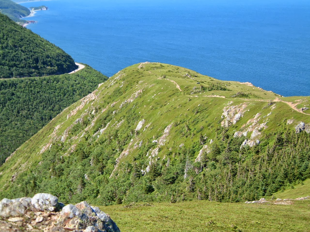
| View of Skyline Ridge from the Cabot Trail |
The Cabot Trail on Cape Breton Island in Nova
Scotia is a 185 mile driving loop that is famous for its views,
especially the northern third that traverses Canada ’s
Cape Breton Highlands
National Park
You may want to do more than just sit in a car, though. Maybe you want to take some easy hikes
(walks, really) that will allow you to explore some of these views at a more
leisurely pace. That is what this post
is about.
Skyline Trail:
This is a very popular trail in the park. This is due to a combination of being
relatively easy, well maintained, easily accessed, and very scenic. The first few tenths of a mile are a wide,
almost flat trail. You will come to a
junction where a trail leads off to the right, allowing you to loop out through
the foliage for possible views of wildlife.
For now stay on the main trail.
 |
| My brother-in-law George with the Cabot Trail to the south |
 |
| The end of the Skyline Ridge. The worn trail is no longer open to hikers. |
It will start to slowly descend as you move along the ravine
to the left. There are places where you
have spectacular views to the south. As
you continue along the main trail you will come to another junction. This is where the trail that left early on
now reconnects. Turn left and continue
along the now combined path. The trail
will be replaced by boardwalk and stairs that were put in place to protect
the vegetation on top of the Skyline Ridge.
You will see where some trails have been worn by footsteps prior to the
building of the protection. These are no
longer active trails. Do not step off
the boardwalks. There are no railings on
these boardwalks (so as to not block the view), so if you have small children
or dogs with you keep an eye on them to ensure they stay on the trail. This is not just
to protect the vegetation, but also to keep them from harm. There are some steep slopes just off this
boardwalk and once someone started to fall they might not stop for a while.
 |
| Tourist on the steps leading down to the end of the Skyline Trail |
 |
| The land falls away to both the right... |
 |
| ...and left |
 |
| Looking back into the interior as the Cabot Trail winds its way north |
 |
| Looking down the coastline as the Cabot Trail winds its way south |
There are several benches and places to sit when you reach
the end of the trail. There are many
viewing platforms. There were a couple
dozen people there on what was a crystal clear day. There was also a Park Ranger and she was
answering questions. I asked about some
land I could see way out in the ocean. I
knew that the Magdalen Islands were out in the Gulf
of St , Lawrence , but I thought they had to be way
too far away to see. She assured me that
we were high enough up that those were what I was seeing. She did remark that she might not ever have
seen them better than that day. They
were sixty miles away and the air was so clear I could even make out two
distinct land masses. My camera was not
good enough to pick up what my naked eye could, though.
 |
| The end of the Skyline Trail with the many viewing areas for visitors |
While whale watching is another thing that some do at the end of the Skyline Trail, I did not see any that day. On the way back I did see a bull moose with its horns in velvet, though. My brother-in-law George is actually the one who spotted it and pointed it out to me. We had chosen not to do the other path to get back to the start because we were going to do a couple of other trails right after this one. We headed straight back the trail we came in on for a cumulative distance of about 4.5 miles. If we had taken the other trail back it would have added about 1 to 1.5 more miles.
 |
| It's a little tough to see, but there is a bull moose with his horns in velvet in the center of the picture |
This trail does drop a couple hundred feet from start to
finish, so on the way back you will be walking uphill. It’s not too bad, though, and the trail is
very well maintained and wide enough for side by side hiking. If you are going to walk only one trail on
your trip to this area then I recommend you do this one.
Bog Trail:
This is the next trail you come upon about two miles north
of the entrance to the parking for the Skyline Trail. It is a quarter mile boardwalk loop through a
bog. There are several panels explaining
what you are seeing and the ecology and science of the bog. As with the Skyline Trail, there are no
railings on the boardwalk so you will need to attend to small children and dogs
if you have them with you. Someone in a
wheelchair can traverse this boardwalk.

On another day this walk might have been quite fascinating,
but after the beauty of the Skyline Trail it just seemed to pale in
comparison. I did not even take any
pictures here. The one I have
accompanying this section I found online.
If you are the owner of this picture and would like me to remove it,
please let me know. If you are thinking
of doing this walk in addition to the Skyline Trail then you may want to do
this one first.
Benjies Lake Trail:
About a half a mile north of the parking for the Bog trail
is the location of the Benjies Lake Trail.
You may choose to walk the gap in between or you can drive and park on
the left. The trailhead is across the
road. It is a fire road for the first
half mile or so. It rises gently at
first, and then descends a little more rapidly to Benjies Lake Brook. Look for a sign on the right for when the
trail leaves the fire road.
 |
| A plant growing near the shore of Benjies Lake |
This final section is a combination of regular trail and
some boardwalks over wet areas. It
descends to the shore of Benjies Lake . Like the Skyline Trail, this spot also has a
reputation for chances to see wildlife, but this day all we saw were a family
with small children that had arrived there before us. Their noise would have scared off anything
that might have wanted to approach.
There is a bench here for you to sit and look at the view. The kids were constantly in the way, so I did
not get a picture looking out over the lake.
I found this one of the moose in the lake online. If you are the owner of this picture and would
like me to remove it, please let me know.

Once you are done taking in the view, simply return back out
the trail that you came in on. The
roundtrip is about 1.5 to 2 miles, with elevation changes that are not too
bad. It’s still more a walk than a hike.
Cumulative
distance:
6.5 miles
Cumulative elevation gain: 300 feet
Cumulative
duration: 3.5
– 4 hours (including time for photos)
Thank you for your beautiful blog. I am developing a mobile app for tourism in Cape Breton and I would like to know if you are willing to share some of the photo's and may be reviews on our app? Please let me know what is the best way to get in touch if you are interested.
ReplyDeleteThank you,
Sam
You can email me at golf04330@yahoo.com
Delete