 |
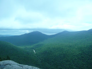
| Looking south from Table Rock |
Table Rock is located in Grafton Notch State Park in Grafton Township, Maine Appalachian Trail , then over to Table Rock, then down the Table Rock trail.
Specific Directions (see General Directions in the Grafton Notch header post here): Drive north on Route 26 past Moose Cave. You will see a big sign that tells you the turn for Table Rock and other hikes is coming in 1,500 feet. It will be on the left. There is parking for many vehicles. There are bathrooms here, but no drinking water.
Note: The state park asks for two dollars for each adult; children under 12 are free. There are no guards or gates to stop at. It is on the honor system. Each park site has a metal column to slide the money in. Paying at one site covers you for all the other sites in the park.
This parking area is a popular starting point for hikes. The Appalachian Trail crosses here and people day hike on it both east and west. Heading west takes you to a loop hike to The Eyebrow, and further on the AT takes you to the trailhead for Old Speck, the third highest mountain in Maine
By the parking area will be a board with places for people to put info for hikers. It also has a rough map of the trails in the area. While facing this board take the trail to the right. You will soon cross over Route 26. In about a tenth of a mile Table Rock Trail will head off to the right. Stay on the Appalachian Trail .
The trail is wide, but because of the foot traffic it sees, if it is wet it can get muddy. It rises moderately and steadily. At nine tenths of a mile there will be another trail heading off to the right to go to Table Rock. Take it. This trail has blue blazes to mark the way. (The AT had white blazes, of course.) This trail is pretty much level all the way to Table Rock. It is about five tenths of a mile.
The view from Table Rock encompasses much of Grafton Notch. The view to the south is a little more open than the view to the north. The day I was there the wind was blowing so hard that one time it actually made me take a step to catch my balance. There is nothing between you and the drop off Table Rock except air, so mind how close you get to the edge.
 |
| Looking up at Table Rock from Route 26 |
 |
| Looking south down Grafton Notch from Table Rock |
 |
| Looking west across Grafton Notch from Table Rock |
 |
| Looking north up Grafton Notch from Table Rock |
When you are done admiring the view, head back to the trail. Look to your right as you come off the rock. There will be a thin, steep gouge in the ground. This is where Table Rock Trail comes up. You may need to use your hands to get down this first little section.
The trail continues to drop somewhat steeply until it reaches some massive slabs of rock. These slabs create cave-like openings. The trail switches back and forth a couple of times as it makes its way down over the rocks. Unlike the other attractions in the state park, you should have real hiking footwear for this trail. I met two men trying to make their way up the trail barefoot. They had found that Crocs don’t make a very good hiking boot, so they had taken them off and were carrying them, while hiking barefoot.
Once past the rocks the trail continues down until it flattens out at a marsh. The trail now drops gently down to where it reconnects with the AT. Turn left onto the AT and follow it back across Route 26 to the parking area.
Cumulative distance: 2.4 miles
Cumulative elevation gain: 900 feet
Cumulative duration: 2 hours
Maine Mountain Guide
No comments:
Post a Comment