 |
| Jordan Pond as seen from the northern shore |
Many people who visit Acadia National Park in Maine either drive or hike to the summit of Cadillac Mountain Sargent Mountain Penobscot Mountain Sargent Mountain and summits Penobscot Mountain
Directions – Drive about one mile north up the Park Loop Road Park Loop Road
Approaching Sargent Mountain shore of Jordan Pond Deer Brook Trail
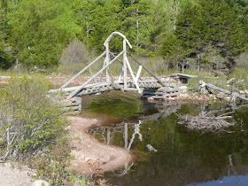
 |
| Wooden bridge at the northern end of Jordan Pond |
Note: I actually parked at the Bubble Rock hiking area and took the Bubbles Divide Trail over to the shore of Jordan Pond
 |
| Deer Brook Bridge on the Deer Brook Trail |
After crossing the carriage road the trail continues to rise to a four way intersection. Take the trail to the right – East Cliffs Trail
 |
| Jordan Pond as seen from the Sargent Mountain East Cliffs Trail |
The steepest section is done when you get above the treeline on the east slope of Sargent. There are good views to the north here. Follow the cairns
 |
| View of Eagle Lake and Frenchman Bay from the eastern slope of Sargent Mountain |
 |
| View of Jordan Pond and the Atlantic Ocean from the eastern slope of Sargent Mountain |
There are 360 degree views from the summit. It is relatively flat at the top of Sargent, though, so some views immediately to the south and northeast are blocked by ridges. Views further in those directions are still plentiful. I could see birds riding thermals over the southern ridge. I met one woman coming up Sargent from another trail (there are four ways to the summit), but she was the first person I had seen the entire hike to that point.
 |
| View of Acadia, Beech, Mansell, and Bernard Mountains from the summit of Sargent Mountain |
 |
| View of the northern end of Somes Sound from the summit of Sargent Mountain |
When you are done at the summit, head down the South Ridge Trail. The views are wide open as you stay above the tree line for quite a ways. Pass the Maple Spring Trail and the Hadlock Brook Trail
 |
| Looking down the south ridge of Sargent Mountain |
 |
| Looking to the west from the south ridge of Sargent Mountain |
 |
| Flowering shrubs growing in a crack in the ledge |
 |
| View of the summit of Penobscot Mountain from the south ridge of Sargent Mountain |
It looks like the valley between the two mountains is very deep, but this trail doesn’t drop as much as I was expecting. You go back down into the trees and then come to a small pond (Sargent Mountain Pond). Continue past it and you will come to a trail junction with the Deer Brook Trail
 |
| Sargent Mountain Pond on the Penobscot Mountain Trail |
The views from Penobscot are blocked in the direction of Sargent, of course, but you could see in all the other directions. There was a couple already at the summit that I talked with for a while. They had come up Penobscot’s southern ridge. After they left another couple also came up the same way. The entire hike I only met a total of five people. When I was done here I retraced my steps back down to the Deer Brook Trail
 |
| View of the Cranberry Islands from the summit of Penobscot Mountain |
 |
| View back at Sargent Mountain from the summit of Penobscot Mountain |
Turn right onto Deer Brook Trail East Cliff Trail Deer Brook Trail
 |
| Beavers have been hard at work on this tree on the shore of Jordan Pond |
Turn left and follow the shore back to the Jordan Pond Carry Trail. Be careful not to take the Bubble South Ridge Trail which reaches the Jordan Pond shoreline at the same spot as the Jordan Pond Carry Trail. Follow the Jordan Pond Carry Trail back up a steady, easy rise to whichever of the connecting trails you came in on. Turn right onto the connecting trail and you will quickly come out to where you parked.
Recommended hike:
Cumulative distance: 4.7 miles round trip
Cumulative elevation gain: 1,450 feet
Cumulative duration: 4 hours, plus 1 hour combined at the two summits
Acadia Hiking Guide
Acadia Hiking Guide
Chip we hooked you up with the new and improved Liebster Blog Award http://3guys1movie.com/?p=5801
ReplyDeleteThanks. I received it a couple weeks ago. I answered your post at your blog.
Delete