Pages

Sunday, July 22, 2012

Hike – Mount Battie, Megunticook Mountain, and Maiden Cliff

Cross overlooking Megunticook Lake at Maiden Cliff
Mount Battie and Megunticook Mountain are located in Camden Hills State Park in Camden, Maine.  They represent the finest coastal mountain hiking outside of Acadia National Park.  Maiden Cliff is just outside of the park and overlooks Megunticook Lake.  This post is a supplement to my original Mt. Battie and Megunticook Mountain post.  It covers the same start, but also includes a complete traverse of Megunticook Mountain all the way to Maiden Cliff.

Note – this is not a loop hike.  It starts and ends at two different places so two vehicles will be needed to shuttle between them.  If you only have one vehicle, or do not wish to do the entire traverse, then please see my post on just hiking Mt. Battie and going up to the Ocean Lookout on Megunticook Mountain.  You can read that here.  It also has many more photos from Mt. Battie and Ocean Lookout.  If you are just interested in hiking Maiden Cliff then continue reading.

Directions – Camden is on Route 1.  From the South you can either stay on Route 1 all the way or bypass Rockland by taking Route 90 off Route 1 in Warren.  When you connect back to Route 1, turn left.  There are 30 miles of trails in the State Park.  If you do not have a map go to the park entrance, which is a couple of miles past Camden's downtown on Route 1, and they will give you one.  Because you are not starting the hike in the park, you will not have to pay an entrance fee.

To drop the first vehicle off take Route 52 off of Route 1 in Camden.  Drive 2.8 miles.  On your right there is a parking area up off the road.  There will be no signs for it.  There is room for a dozen vehicles or more.  This is the parking for the Maiden Cliff trailhead.  If you are only interested in this hike then the trailhead is on the far end of the parking area.  I will have a short description of that, as well as elevations, durations, etc. at the end of this post.

To get to the starting trailhead for Mt. Battie take Route 52 back towards Camden.  Watch for a cemetery on your right.  After the end of it start watching on your left for the first street.  This is Spring Street, but there is no street sign.  You will have to look for a stop sign.  Turn onto it.  In less than a tenth of a mile take a left onto Megunticook Street Extension.  There was a street sign for this.  It will look like you are driving into someone's driveway, but you are not.  Drive up to the end of this street and there is parking for about eight vehicles.

The trail starts at the back of the parking area.  There is a sign warning that the trail is closed from sundown to 6:00 AM.  The ½ mile trail breaks into three sections of about the same length, with the bottom and top sections having gradual rises and the middle section having a very steep rise.  You will need both hands free to make it up over the middle section safely.  I would have said wear proper footgear and don't bring dogs, but I would have been wrong.  I passed a man hiking up this section in boat shoes and I met a couple coming down with two dogs.  The owners had to coax them down over the steeper sections, but the dogs made it.

Once you get over the steep section you will come to a ridge with great views of Camden Harbor.  In my opinion, the harbor view here is superior to the summit since you are more aligned with it.  At the summit you are more to the side.  Once you have taken your pictures you can ascend easily to the summit.  

Camden harbor from the Mt. Battie Trail
Note - there are a great many cairns built on this trail, almost none of which point you in the correct direction.  There is even a place where there are dozens that people have created.  This is a very popular hiking trail.  My guess is that people don't understand what the cairns are for and everyone has created their own.  Always follow the blue blazes on this trail.  They will steer you correctly.

Some of the many cairns on the Mt. Battie Trail
Mount Battie has an auto road to the top, just like Mount Washington and Cadillac Mountain.  This means there are many tourists at the summit.  Unless you want to get away from the people, spend some time exploring all the views available here.  There is a stone tower erected as a memorial to the soldiers in World War I.  You have 360 degree views from the top of it.  There are displays that identify each of the islands and peninsulas you can see from the summit.  There is also a passage from a poem that Edna St. Vincent Millay wrote that describes the view from Mount Battie.  Walk to the parking lot and then follow the road to the right until you reach even more views.  There are pay binoculars here that you can use to see the sights.  There are also bathrooms at the summit (off to the left of the parking lot), but no drinking water.

Camden Harbor from Mt. Battie
(Note – see my original post here for more pictures from Mt. Battie.)

When you are done here, cross over the parking lot to the trailhead for the Tablelands Trail.  The blue blazes continue and there are far fewer cairns.  At one point I came to a ledge that went left and right, but I could not see any blazes.  After exploring for a few minutes I finally found the next blaze hidden between two small bushes almost in front of where I stepped onto the ledge.  Go between the bushes and into the trees on the other side.

This trail drops for .5 miles until it meets the Mount Battie Auto Road.  Cross over the road and the trail continues to the left of a parking area.  It is one mile further on this trail to Ocean Lookout.  The trail continues to drop for another .3 miles until you reach a stream.  At this point the Nature Trail branches off to the right.  Stay on the Tablelands Trail.

You will now ascend the rest of the way on this trail.  While not as steep as the Mount Battie trail, it is at least a moderate rise.  As you ascend you will pass the Carriage Trail coming in on the left, the Jack Williams trail coming in on the left and then you will come to where the Adam's Lookout trail comes in on the right.  Continue up to Ocean Lookout up the Tablelands Trail.  (For a brief description of a side trip to Adam’s Lookout please see my original post here.)

At Ocean Lookout you have fantastic views of Camden Harbor, Mount Battie, the hills to the north of Camden, and various islands, including Mount Desert Island and Cadillac Mountain.  There was a natural bench in the rock that I used to sit down, lean back, and enjoy the views. 

Hazy view of Camden Harbor from Ocean Lookout
(Note – see my original post here for clearer pictures from Ocean Lookout.)

The first time I was here I wanted to traverse Megunticook to Maiden Cliff, but could not.  This time my nephew had joined me and we did just that.  Leave Ocean Lookout on the opposite side of where you came up.  This is the Ridge Trail.  It runs 2.5 miles to Maiden Cliff.  There are a series of small ups and downs to get to the true summit of Megunticook about .5 miles in.  After this you will pass Slope Trail coming in from the right, Zeke’s Trail coming in from the right, and finally Jack Williams Trail coming in from the left.  There will be one or two places where you can see out, but for the most part this is a wooded trail that descends gently to moderately, with occasional small rises.

View of Megunticook Lake from Ridge Trail heading towards Maiden Cliff
At about 2 miles in you will come to the junction with Scenic Trail.  Heading left will take you down to a junction with Maiden Cliff Trail.  Both Maiden Cliff and Scenic Trail head to the same end point, so take Scenic Trail.  The path will rise a couple hundred feet to an expansive view of Megunticook Lake. 

Looking back at Megunticook from Ridge Trail/Scenic Trail junction.  Note the bird riding the thermals.


After this the trail goes back into the trees and descends towards Maiden Cliff.  When you come to the junction with Maiden Cliff Trail you will see several worn paths leading to openings.  Explore all of these as each gives a somewhat different view.

Maiden Cliff is so named because a 12 year old girl lost her life in 1864 when she fell from it.  There is a large cross and a stone marker there to remember her.
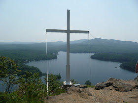
The cross for Elenora French at Maiden Cliff.  Megunticook Lake is in the background.
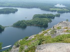
Looking at the northern end of Megunticook Lake and the hills and ponds beyond.


An island in Megunticook Lake
Photo 1 of 4 showing a panoramic view from another scenic overlook at Maiden Cliff.
Photo 2 of 4 showing a panoramic view from another scenic overlook at Maiden Cliff.
Photo 3 of 4 showing a panoramic view from another scenic overlook at Maiden Cliff.
Photo 4 of 4 showing a panoramic view from another scenic overlook at Maiden Cliff.
When you are done here, retrace your steps to the junction of the two trails.  Take Maiden Cliff Trail (the one on the right).  It will have a brief rise, but will then descend first gently, then moderately.  It is a wide, well-worn path.  It is wooded, so there are no views out to the lake from the trail.  You will pass Ridge Trail coming in from the left.  Stay on Maiden Cliff Trail.  In a little over a half a mile from here you will come out to the parking area you left the first vehicle at.  Drive back to the starting point to pick up the other vehicle and you are done.

If you want to hike only Maiden Cliff:

Follow the directions above for parking the first vehicle.  Take the trail off the far end of the parking area.  This is Maiden Cliff Trail.  It ascends moderately for about .5 miles where Ridge Trail will come in on the right.  Stay on Maiden Cliff Trail.  It will rise a little more steeply before finally flattening out as you near the trail junction with Scenic Trail.  See above for pictures and more info on Maiden Cliff.

When you are done, return to the trail junction.  You can retrace your steps, but if you want to make this a loop hike, take Scenic Trail (the left one).  This will rise moderately for a short distance before rising more gently.  It will come to an expansive, open view of Megunticook Lake (see above). 

You will come to a trail junction with the Ridge Trail heading both left and right.  Take Ridge Trail right and you will descend .3 miles back to Maiden Cliff Trail.  Turn left onto Maiden Cliff Trail and descend back to the parking area.

Mt. Battie, Megunticook Mountain, Maiden Cliff Traverse:

Cumulative distance:             5.6 miles
Cumulative elevation gain:   2,400 feet (including the smaller rises on the trails)
Cumulative duration:            5.5 hours (including stops to enjoy the views and eat lunch)

Maiden Cliff loop hike (using both Maiden Cliff and Scenic Trails):

Cumulative distance:             1.8 miles
Cumulative elevation gain:   700 feet
Cumulative duration:            1.75 hours (including time to enjoy the views)

Maiden Cliff up and back hike (using only Maiden Cliff Trail):

Cumulative distance:             1.6 miles
Cumulative elevation gain:   550 feet
Cumulative duration:            1.5 hours (including time to enjoy the views)

Maine Mountain Guide

2 comments:

  1. this was a very fun hike deffinitley worth it for the views alone . and over all it wasn't to difficult . remember to bring a friend with another car makes it much easier

    ReplyDelete